
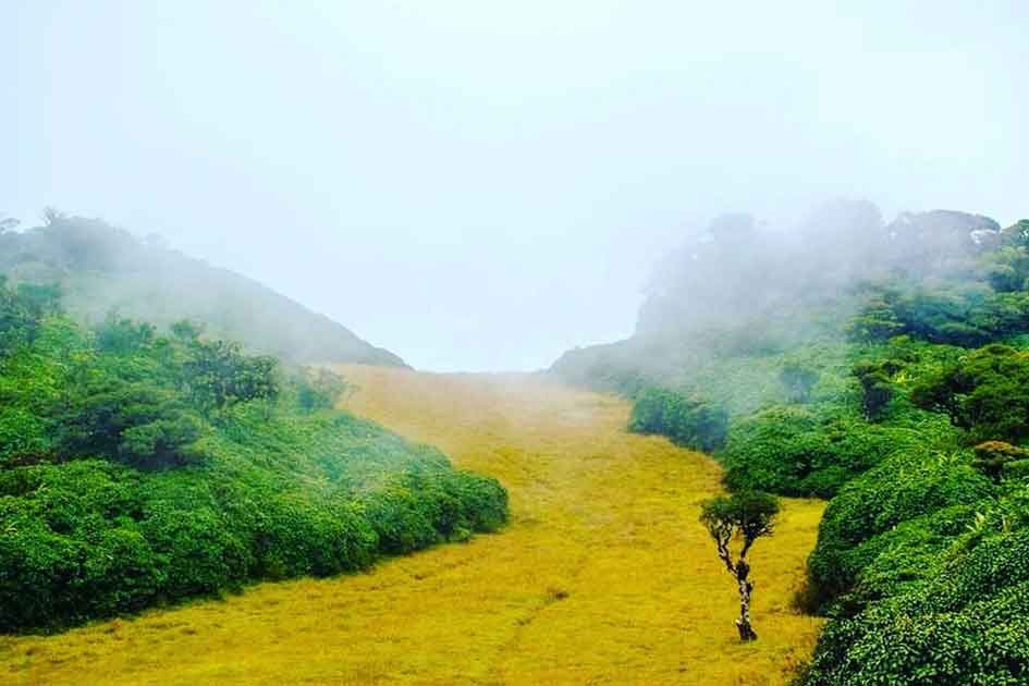
Chariot Path of King Rawana is a grassland (Plain) on top of a mountain range that is surrounded by a pigmy forest, which looks like a pathway. It is a wonderful place, which has breathtaking views and an unspoiled, extraordinary environment. This is located near the Frotoft Tea Estate in the Kandy District of the Central Province, Sri Lanka.
Introduction
The chariot path is the route on which Ravana transported Sita Devi on his chariot from Sita Kotuwa to Ashoka Vatika, also known as the Ravana grass pathway, located in the jungle at the top of the Ramboda Hills on the Kandy–Nuwara Eliya main road. This is one of the iconic Ramayana sites in Sri Lanka. To date, no vegetation grows on this barren land except grass. King Ravana is believed to have used this passage on top of these hills to show Sita Devi the beauty of his kingdom, as stated in the great epic of Ramayana.
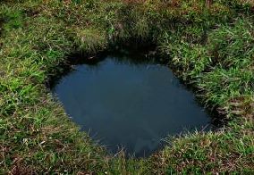
The Sita tear pond is a small pond situated along the chariot path. A pond located on this Chariot Path is believed to have been formed here by the tears of Sita Devi and has not dried up so far, even during severe droughts when the adjoining rivers do. It is situated on top of a mountain range in the central highlands of Sri Lanka, offering spectacular 360-degree views.
The Chariot Path and Sita Tear Pond are important Ramayana Sites in Sri Lanka.
Where Exactly Is the Chariot Path?
The Chariot Path described in this article is located near Frotoft Tea Estate and Perettasi village in the Pussellawa region, between Kandy and Nuwara Eliya in Sri Lanka’s Central Highlands.
This site is sometimes confused online with Ravana Ella Cave near Ella, a completely different location in the Badulla District. While both places are linked to Ramayana folklore and King Ravana, they are geographically separate and should not be mistaken as the same site.
Local travelers and estate communities around Frotoft traditionally refer to this high-altitude grassland as the Ravana Grass Path or Chariot Path, based on its natural pathway-like formation on the mountain ridge.
Chariot Path Location
Best Time to Visit
The ideal time to visit the Chariot Path is during the dry season (December to April) when the weather is pleasant and the trails are easy to navigate. Early mornings offer the best experience, with golden sunlight illuminating the landscape.
How to Reach the Chariot Path?
Reaching the Chariot Path requires an adventurous trek through tea estates, pine forests, and grasslands. Here’s how you can get there:
- By Road: Travel to Nuwara Eliya or Kandy, both of which are easily accessible by car or public transport.
- Starting Point: Begin your trek from Labookellie, passing through Kotmale and Pussellawa.
- Hiking Trail: The trail covers 4-5 km of moderate hiking, with breathtaking views of the highlands.
Chariot Path Distance
From Colombo, it is a 5-hour drive (161.3 km) via the Kandy Road and the Kandy-Colombo Road/A1.
Who Was King Rawana?
Before diving into the details of the Chariot Path, it’s essential to understand the legendary figure behind it. King Ravana (also known as Rawana) is a central character in the ancient Indian epic, the Ramayana.
Known as a mighty king, a skilled warrior, and a devoted scholar, Rawana ruled the island of Lanka (modern-day Sri Lanka) over 5,000 years ago. While he is often depicted as a villain in the Ramayana, in Sri Lankan folklore, Rawana is celebrated as a heroic and wise ruler.
Rawana’s legacy is deeply embedded in Sri Lanka’s culture, with numerous sites across the island associated with his reign. The Chariot Path is one such site, believed to be a testament to his engineering prowess and mystical powers.
What is the Chariot Path of King Rawana?
The Chariot Path, also known as Rawana’s Chariot Track, is a mysterious and ancient pathway located in the Ella region of Sri Lanka. This unique site features two parallel grooves carved into the rock, resembling the tracks left by a giant chariot.
According to local legend, these grooves were created by King Rawana’s flying chariot, which he used to travel across the island.
The Chariot Path is often mentioned alongside Ravana Ella Cave in Ella due to shared Ramayana legends, but the two sites are located in different regions of Sri Lanka and are not physically connected. The cave is believed to have been a hideout for Rawana when he abducted Princess Sita, as narrated in the Ramayana. Together, these sites form a fascinating trail that offers a glimpse into Sri Lanka’s rich and storied past.
The Legend Behind the Chariot Path
The Chariot Path is steeped in legend and folklore. According to the Ramayana, King Rawana possessed a magnificent flying chariot known as the Dandu Monara (Peacock Chariot). This chariot was said to be powered by mystical energy and could travel vast distances in a short time.
Local tales suggest that the wheels of Rawana’s chariot created the grooves on the Chariot Path as he traveled between his palace and the Rawana Ella Cave. Some even believe that the path was used to transport Princess Sita during her captivity.
While these stories are rooted in mythology, they add a layer of mystique to the site, captivating the imagination of visitors.
Why the Chariot Path Is Often Confused With Ella Sites
Many online sources associate the Chariot Path with Ella-based attractions such as Ravana Ella Falls and Ravana Ella Cave. This confusion likely arises because Ella is more established on tourist maps, while the Frotoft–Pussellawa region remains less visited and less documented.
In reality, several Ramayana-linked locations are scattered across Sri Lanka, each tied to regional folklore rather than a single travel route. The Chariot Path near Frotoft stands out not because of nearby monuments, but because of its unusual grassland formation at high elevation, which later became woven into Ravana legends by surrounding communities.
Understanding this distinction helps travelers plan realistically and avoids disappointment caused by expecting Ella-style facilities or viewpoints.
Understanding the Chariot Path Beyond the Legend
Most online articles describe the Chariot Path only through the Ramayana lens. What’s often missing is how local communities actually relate to this place today.
Among estate workers and villagers near Frotoft and Perettasi, the Chariot Path is not discussed daily as a mythological monument. Instead, it is viewed as a windswept highland grass corridor that behaves very differently from surrounding forest land. Locals notice that mist moves faster here, lightning strikes are more frequent during monsoon storms, and grass regrows unevenly after heavy rain.
These observations don’t prove any legend — but they explain why this place stood out long before tourism. Elevated wind channels and shallow soil layers naturally prevent tall vegetation from establishing, which may have contributed to the “path-like” appearance that later folklore attached meaning to.
This perspective helps visitors appreciate the site without needing to believe or dismiss the legend entirely.
What the Walk Actually Feels Like
Most photos online are taken on clear mornings. Reality is different.
Walking the final stretch to the Chariot Path often means:
- Sudden fog reducing visibility to 10–15 meters
- Strong lateral winds that can unbalance you on open ground
- Wet grass that soaks shoes even on dry days
There are no railings, no markers, and no formal trail maintenance. This is not a landscaped viewpoint. Travelers expecting a clearly defined “path” are often surprised — what you see is an open grass plateau where the “path” becomes visible mainly from certain angles and lighting conditions.
This rawness is part of the experience, but it also means visitors must rely on judgment, not signboards.
Why the Grassland Matters (An Angle Rarely Mentioned)
The grassland around the Chariot Path plays a quiet ecological role.
Unlike dense forests, this high-altitude grassland:
- Allows rainwater to slowly percolate into underground channels
- Acts as a buffer zone between tea estates and forest reserves
- Supports insects and bird species rarely seen inside plantations
Estate workers sometimes avoid burning this grass (a common practice elsewhere) because regrowth here is unpredictable. This may explain why the area remains visually distinct even decades after surrounding land use changed.
For travelers, this means:
- Stay on existing footpaths where possible
- Avoid trampling new grass patches
- Never attempt camping or fires
Preserving this fragile environment ensures the site remains untouched — not “improved” into something artificial.
Navigation Tip You Won’t Find on Google Maps
Mobile signal often drops completely near the top. Google Maps can show you near the area but not the final approach.
A practical local method:
- Save the Frotoft Estate old hospital location offline
- Ask estate workers for “the open grass hill above Perettasi”
- Start early enough to turn back if fog thickens by noon
If visibility drops suddenly, experienced hikers stop moving forward — not because the terrain is dangerous, but because landmarks disappear fast.
How Much Time to Spend (Realistic Advice)
Many blogs say “half a day.” That’s misleading.
A realistic breakdown:
- Approach hike (slow, careful): 2–3 hours
- Time at the grassland: 45–60 minutes
- Descent: 1.5–2 hours
Most visitors leave earlier than planned because:
- Wind exposure becomes tiring
- There is little shelter
- Weather changes rapidly
This is a short but mentally demanding hike, not a picnic spot.
Visiting With the Right Mindset
The Chariot Path is not impressive because of structures, ruins, or facilities. It’s powerful because it feels unfinished and uninterpreted.
You won’t find plaques explaining what to believe.
You won’t be told where to stand for the “correct view.”
And that’s the point.
Whether you see a legendary route, a geological anomaly, or simply a dramatic highland corridor depends entirely on how quietly you observe it.
Exploring the Chariot Path: What to Expect
Visiting the Chariot Path is a unique experience that combines history, nature, and adventure. Here’s what you can expect during your visit:
- The Rock Carvings: The most striking feature of the Chariot Path is the two parallel grooves carved into the rock. These grooves are approximately 1.5 meters apart and extend for several meters in length. The precision and depth of the carvings have puzzled archaeologists and historians, leading to various theories about their origin.
- Scenic Surroundings: The Chariot Path is surrounded by Ella’s breathtaking landscape. As you explore the site, you’ll be treated to stunning views of verdant hills, tea plantations, and the distant peaks of the central highlands.
- Rawana Ella Cave: A visit to the Chariot Path is incomplete without exploring the nearby Rawana Ella Cave. This ancient cave is believed to have been used by King Rawana as a hideout and offers a fascinating glimpse into Sri Lanka’s prehistoric past.
- Hiking Opportunities: The trail to the Chariot Path is a short but rewarding hike. Along the way, you’ll pass through lush forests and open meadows, making it a perfect activity for nature lovers.
How to get to Chariot Path
A person who starts their journey from Colombo should first reach Gampola. After arriving at Gampola, take a bus to Pussallawa village. From there, you’ll need to hire a car to get to the Frotoft estate. The roads are in poor condition, so make sure you rent a car that can handle a rough ride.
You may also take the bus; however, the trips to Frotoft State/ Perettasi village are inconsistent and infrequent. Hiring a car is therefore considerably simpler. It takes 1.30 -2 hours to reach Perettasi village/Frotoft estate. You must first locate the Frotoft state’s/Perettasi village old hospital facility, and the trailhead starts there.
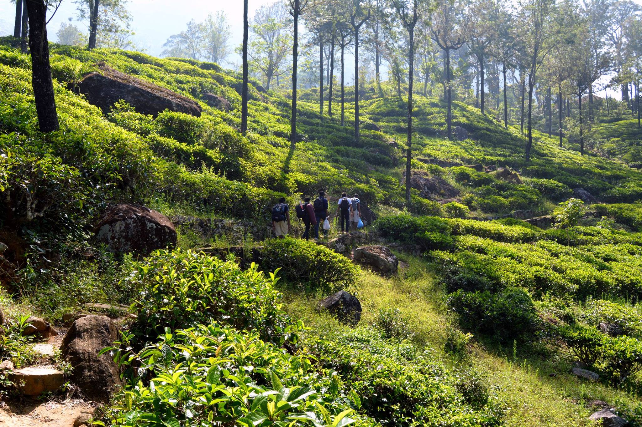
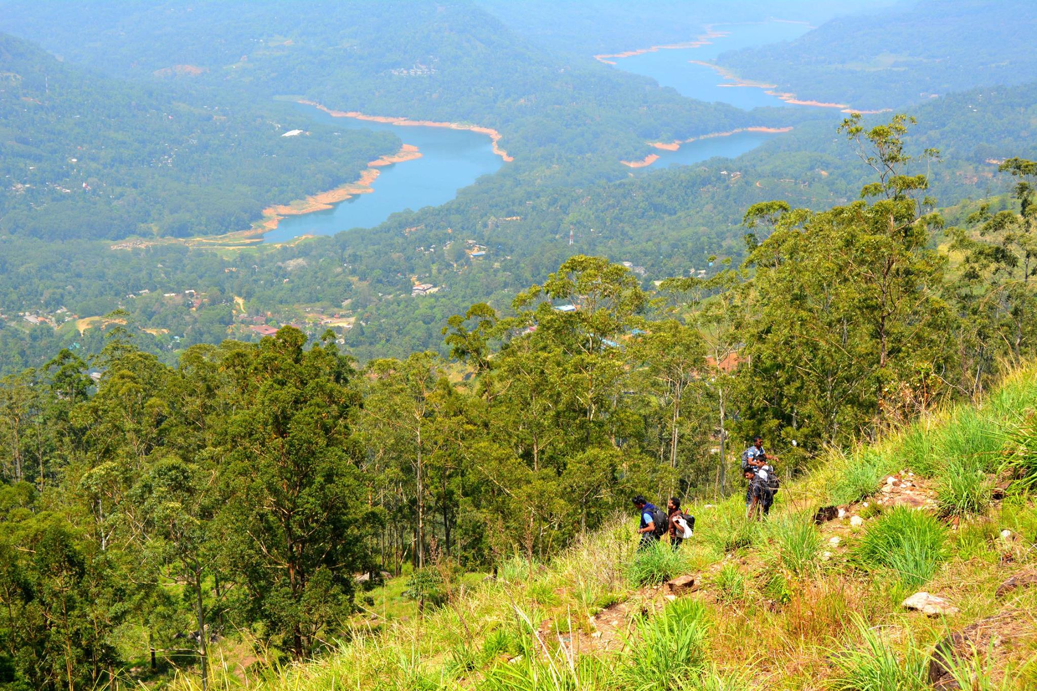
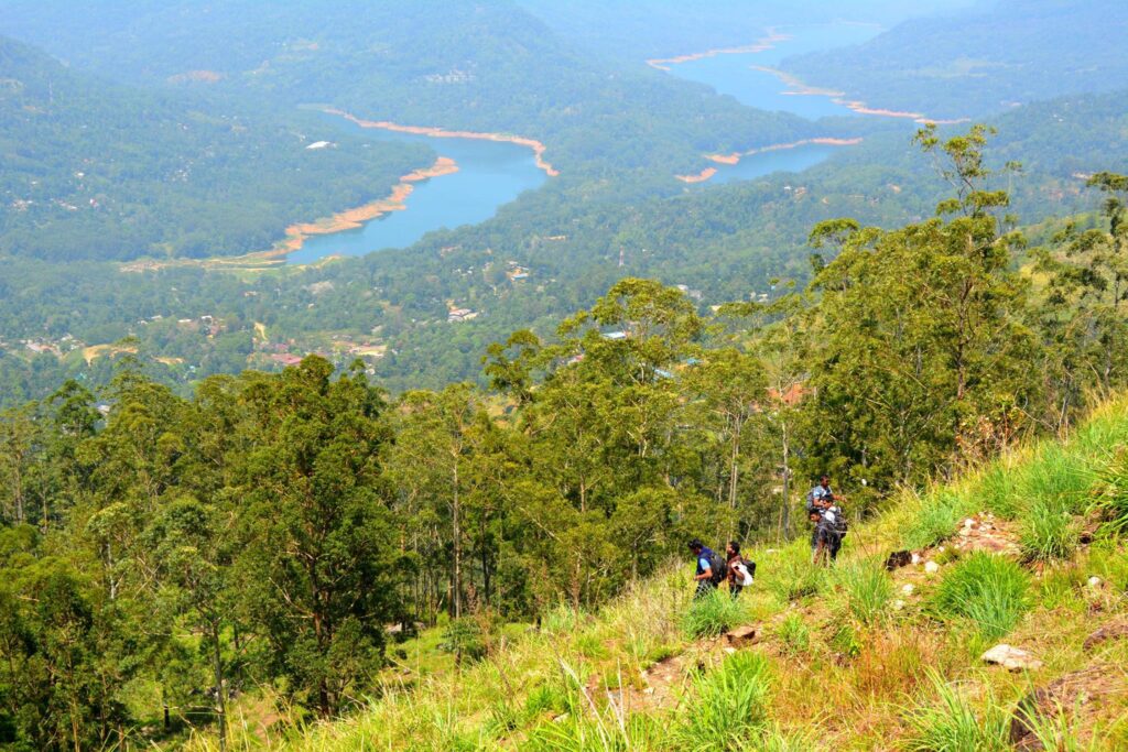
Journey through the tea estate was not a difficult task. But when it starts to climb, it is a footpath that lies along the whole journey towards the slope. So, be careful. It will take 2-3 hrs to the top of the mountain range. The chariot path is surrounded by the Kotmale reservoir, Pidurangala, Hanguranketha, Sri Padaya, and Hewaheta, providing eye-catching surroundings throughout the journey. It takes at least half a day to spend there at this excellent Ramayana site.
Be ready for the chilly weather. In addition, there are wind conditions at night. Also, bring a sweater or hat to protect yourself from the sun. Wear a long-sleeved shirt or t-shirt as well. Because you will be passing through grasslands, wearing long sleeves will protect you from cuts and scratches caused by the spiky grass.
It is not possible to reach this place easily, and it is not a suitable place for senior citizens and people who are suffering from heart problems or respiratory illnesses.
Chariot Path Weather
Most of the year, the Chariot Path receives rainfall. The temperature ranges from 10°C to 24°C. Between October and January, heavy monsoon rains fall. The months of February through April are ideal for visiting the Chariot Path. Between these months, the majority of the days are bright, with the least amount of rain.
Tips for Visiting the Chariot Path
- Wear Comfortable Shoes: The trail to the Chariot Path involves some walking, so be sure to wear sturdy and comfortable footwear.
- Bring Water and Snacks: Although the hike is short, it’s always a good idea to carry water and light snacks, especially during the warmer months.
- Respect the Site: The Chariot Path is a place of historical and cultural significance. Be mindful of your surroundings and avoid damaging the rock carvings.
- Visit Early or Late: To avoid the midday heat and crowds, consider visiting the Chariot Path early in the morning or late in the afternoon.
FAQ
1. Where exactly is the Chariot Path in Sri Lanka?
The Chariot Path is located near Frotoft Tea Estate and Perettasi village in the Pussellawa region, between Kandy and Nuwara Eliya in Sri Lanka’s Central Province. It sits on a high-altitude grassland ridge surrounded by tea estates and forest patches, not near a major tourist town.
2. Is the Chariot Path located in Ella?
No. The Chariot Path described here is not in Ella.
This site is often confused with Ravana Ella Cave and Ravana Ella Falls, which are located in Ella (Badulla District). While both places are linked to Ramayana legends, they are geographically separate and several hours apart.
3. Why do some websites say the Chariot Path is near Ravana Ella Cave?
Many websites associate the Chariot Path with Ella because Ella is more widely known to tourists. Over time, different Ramayana-related locations across Sri Lanka have been grouped together online, even when they are not physically connected. Locally, the Chariot Path near Frotoft is recognized as a separate highland site.
4. Are there multiple places in Sri Lanka called the Chariot Path?
There is one well-known Chariot Path (Ravana Grass Path) near Frotoft and Pussellawa. However, several locations across Sri Lanka are linked to King Ravana through folklore, which leads to confusion. Not all Ravana-related sites are part of a single route or region.
5. Is the Chariot Path connected to Ravana Ella Falls?
No. The Chariot Path near Pussellawa is not physically connected to Ravana Ella Falls in Ella. The connection between them exists only through shared mythology, not geography or walking trails.
6. How far is the Chariot Path from Ella?
The Chariot Path near Frotoft is approximately 90–110 km from Ella, depending on the route taken. Travel time can range from 4 to 5 hours by road, as the journey passes through winding hill roads.
7. Which district does the Chariot Path belong to?
The Chariot Path is located in the Kandy District, within Sri Lanka’s Central Province. It is closer to Pussellawa and Kotmale than to Nuwara Eliya town or Ella.
8. Is the Chariot Path easy to find on Google Maps?
Not always. Google Maps may show nearby estate roads, but the final approach is not clearly marked. Visitors are advised to navigate to Frotoft Tea Estate or Perettasi village, then ask locals or estate workers for directions to the grassland path.
9. Can I visit the Chariot Path and Ella attractions on the same day?
Practically, no. Due to distance, road conditions, and hiking time, visiting the Chariot Path near Pussellawa and Ella attractions on the same day is not realistic. These locations are better planned as separate trips.
10. Why is the Chariot Path less known compared to Ella sites?
Unlike Ella, the Chariot Path has no developed tourist facilities, signboards, or viewpoints. Its remote location and estate-based access have kept it off mainstream travel routes, which is also why it remains relatively untouched.
Video
If you’ve visited Chariot Path, feel free to share your experience in the comments below and inspire other travelers to discover this incredible destination.
By Tour My Lanka Editorial Team
– promoting sustainable and authentic travel across Sri Lanka.
Last Updated: January 2026
Images in this article are for illustration purposes and sourced from royalty-free platforms such as Pixabay and Unsplash.


